pinecreekvalley.com sponsors the Pine Creek Rail Trail Facebook Page:
https://www.facebook.com/groups/PineCreekRailTrail/
Check this page for information about Rail Trail conditions, great pictures of scenery and wildlife, and other information.

Info:
More information can be found here:
https://www.traillink.com/trail/pine-creek-rail-trail/
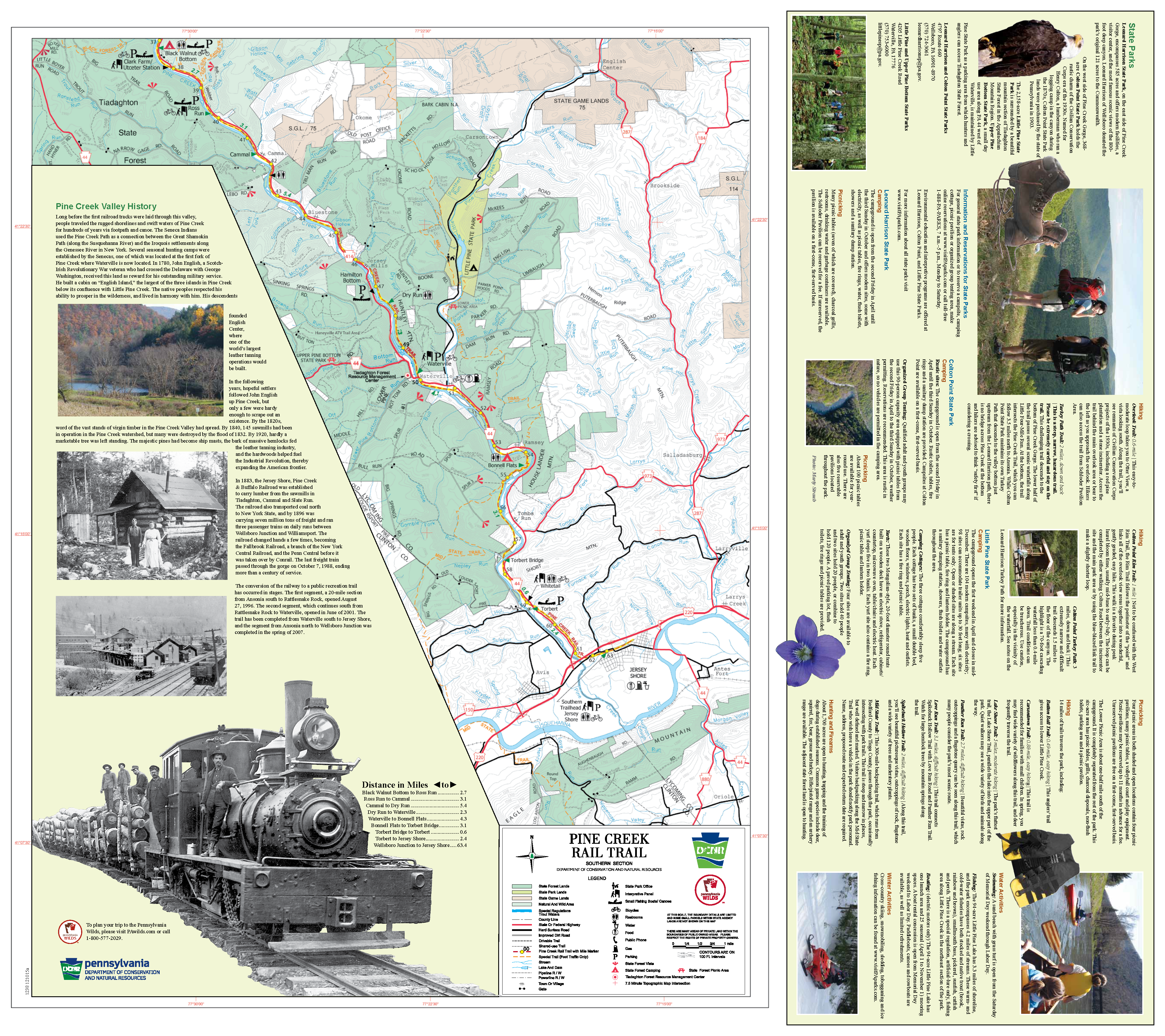
The Pine Creek Rail Trail is one of Pennsylvania’s destination trails, and for good reason. The 62-mile well–maintained trail runs at the bottom of überscenic Pine Creek Gorge, commonly called the Grand Canyon of Pennsylvania. Small towns along the route cater to trail visitors, and numerous trailheads, comfort stations, campgrounds, and lodging make extended stays possible. The finely crushed limestone surface is best suited for hybrid bikes; a service road next to the trail from Ansonia to Tiadaghton Campground (just northwest of where the trail intersects T357/Tiadaghton Road) is open to equestrians as well. It’s a good trail for families, but remember that bicyclists age 12 and under must wear a helmet.
Melting glaciers carved the gorge, which runs 800–1,400 feet deep and a mile wide. A natural travel route through northern Pennsylvania for American Indians, the gorge in 1883 became the route of the Jersey Shore, Pine Creek and Buffalo Railway—later named Pine Creek Railway—that served lumber companies that clear-cut the mountainsides. The last freight passed through in 1988, and the trail was born in 1996 and extended to its present length in 2012.
The trail slopes imperceptibly downhill alongside Pine Creek, from Wellsboro Junction in the north to Jersey Shore in the south. Pines and hardwoods now carpet the bare slopes left behind by loggers. Deer, elk, wild turkeys, and black bears inhabit the area bound by the Tioga and Tiadaghton State Forests, and you might see river otters or beavers in the water and bald eagles or ospreys above. The northern section is bound by state parks, and more food and lodging are available in the south. Visitors can use bike rental and shuttle services, as well as canoe and kayak liveries, and horse-drawn wagon rides are available on some sections.
The trailhead at Wellsboro Junction is the northern starting point (plans are underway for a 3-mile trail connection—the Marsh Creek Greenway—to Wells-boro that will provide more services to visitors). The Tioga Central Railroad station 0.5 mile east hosts an excursion train that runs north.
The first 7 miles to Ansonia are fairly wide open, but the gorge begins forming soon after the trail joins Pine Creek. The route passes between Colton Point State Park on the right and Leonard Harrison State Park on the left. Take the Turkey Path trail at 3.5 miles past the Darling Run trailhead to enjoy waterfall views.
The next 12.5 miles to a store at Blackwell travel through the most remote section of the gorge, passing only the Tiadaghton Campground. After Blackwell, SR 414 follows the trail south as the surroundings become more populated. A good swimming hole lies at Rattlesnake Rock, 1.8 miles past Blackwell, and in another 4 miles, Cedar Run has a popular café.
You’ll encounter numerous trailheads and towns along the final 33 miles to Jersey Shore (the name refers to an early family from New Jersey) on the West Branch Susquehanna River. There’s a store at Slate Run and services at Cammal and Jersey Mills. SR 44 arrives at Waterville, 1,450 feet below the surrounding ridgetops. The trail runs alongside SR 44 into Jersey Shore. Long-range plans call for extending the trail to Williamsport.
Parking and Trail Access
To reach the northern trailhead at Wellsboro Junction from I-180 W, take Exit 29 to merge onto US 15 N. Go 27.6 miles, and turn left onto SR 414. Go 9.8 miles; stay straight on SR 287 N. Go 11.7 miles, and turn right onto SR 287/Main St. Go 0.3 mile, and stay straight on US 6/SR 287/-Roosevelt Hwy. Go 2.5 miles, and bear right to stay on SR 287. Go 0.4 mile; turn left onto Lower Marsh Creek Road. Go 0.1 mile, and turn left onto Butler Road. Go 0.1 mile; turn right into the parking lot.
To reach the southern trailhead in Jersey Shore from I-180 W, stay on US 220 as I-180 ends in Williamsport (past mile marker 29). Go 13.3 miles, take the Thomas St. exit, and turn left onto Thomas St. Go 0.2 mile, and turn right onto Railroad St. Go 0.2 mile, and turn left into the parking lot. The endpoint is about 0.9 mile east along the trail at Seminary St. (facing the railroad tracks, turn left along the Pine Creek Rail Trail).